Marble/MarbleMarbleWidget: Difference between revisions
| Line 15: | Line 15: | ||
Now we want to modify the map: | Now we want to modify the map: | ||
Again [http://api.kde.org/4.x-api/kdeedu/marble/classMarble_1_1MarbleWidget.html MarbleWidget] provides a convenient way to make changes to the overall look and feel: | Again [http://api.kde.org/4.x-api/kdeedu/marble/classMarble_1_1MarbleWidget.html MarbleWidget] provides a convenient way to make changes to the overall look and feel of the map: | ||
We'd like to display a small weather map. So we turn on the satellite view, enable the clouds and enable the country border lines. | |||
<code cppqt> | <code cppqt> | ||
#include <QtGui/QApplication> | #include <QtGui/QApplication> | ||
| Line 58: | Line 56: | ||
floatItem->setContentSize( QSize( 50, 50 ) ); | floatItem->setContentSize( QSize( 50, 50 ) ); | ||
} | } | ||
mapWidget->resize( 400, 300 ); | |||
mapWidget->show(); | mapWidget->show(); | ||
Revision as of 20:43, 5 July 2010
Editing Projects/Marble/MarbleCPlusPlus
Languages: عربي | Asturianu | Català | Česky | Kaszëbsczi | Dansk | Deutsch | English | Esperanto | Español | Eesti | فارسی | Suomi | Français | Galego | Italiano | 日本語 | 한국어 | Norwegian | Polski | Português Brasileiro | Română | Русский | Svenska | Slovenčina | Slovenščina | српски | Türkçe | Tiếng Việt | Українська | 简体中文 | 繁體中文
| Tutorial Series | Marble C++ Tutorial |
| Previous | C++, Qt |
| What's Next | Tutorial 3 - Marble's GeoPainter |
| Further Reading | n/a |
Making changes to the map
Now we want to modify the map:
Again MarbleWidget provides a convenient way to make changes to the overall look and feel of the map:
We'd like to display a small weather map. So we turn on the satellite view, enable the clouds and enable the country border lines.
- include <QtGui/QApplication>
- include <marble/global.h>
- include <marble/MarbleWidget.h>
- include <marble/AbstractFloatItem.h>
using namespace Marble;
int main(int argc, char** argv)
{
QApplication app(argc,argv);
   // Create a Marble QWidget without a parent
   MarbleWidget *mapWidget = new MarbleWidget();
   // Load the OpenStreetMap map
   mapWidget->setMapThemeId("earth/bluemarble/bluemarble.dgml");
   mapWidget->setProjection( Mercator );

   // Enable the cloud cover and enable the country borders
   mapWidget->setShowClouds( true );
   mapWidget->setShowBorders( true );

   // Hide the FloatItems: Compass and StatusBar
   mapWidget->setShowOverviewMap(false);
   mapWidget->setShowScaleBar(false);

   foreach ( AbstractFloatItem * floatItem, mapWidget->floatItems() )
       if ( floatItem && floatItem->nameId() == "compass" ) {

           // Put the compass onto the left hand side
           floatItem->setPosition( QPoint( 10, 10 ) );
           // Make the content size of the compass smaller
           floatItem->setContentSize( QSize( 50, 50 ) );
       }

   mapWidget->resize( 400, 300 );
   mapWidget->show();
return app.exec();
}
Save the code above as my_marble.cpp and compile it:
g++ -I /usr/include/qt4/ -o my_marble my_marble.cpp -lmarblewidget -lQtGui
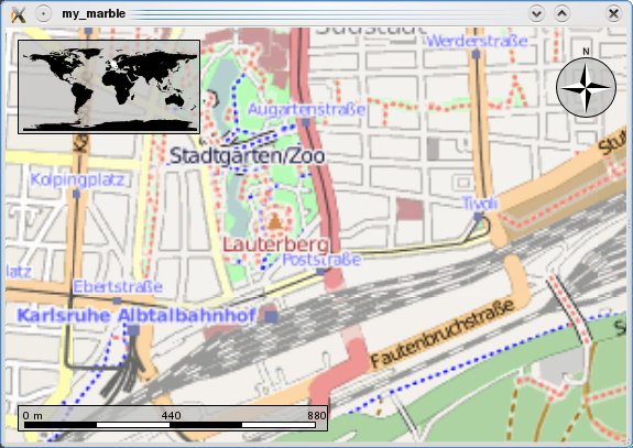
If things go fine, execute ./my_marble and you end up with a fully usable OpenStreetMap application: 
Here's a little checklist to tackle some problems that might arise when compiling the code above:
- You need Qt and Marble development packages (or comparable SVN installations)
- If Qt headers are not installed in /usr/include/qt4 on your system, change the path in the g++ call above accordingly.
- Likewise, add -I /path/to/marble/headers if they're not to be found in /usr/include
