Marble/Runners/DisplayGeoDataPlacemark
Editing Projects/Marble/MarbleCPlusPlus
Languages: عربي | Asturianu | Català | Česky | Kaszëbsczi | Dansk | Deutsch | English | Esperanto | Español | Eesti | فارسی | Suomi | Français | Galego | Italiano | 日本語 | 한국어 | Norwegian | Polski | Português Brasileiro | Română | Русский | Svenska | Slovenčina | Slovenščina | српски | Türkçe | Tiếng Việt | Українська | 简体中文 | 繁體中文
| Tutorial Series | Marble C++ Tutorial |
| Previous | Tutorial 10 - Using the GeoPainter in order to paint GeoDataLineString objects |
| What's Next | Tutorial 12 - Yet missing |
| Further Reading | n/a |
GeoDataPlacemark is a class which implements the features of KML's Placemark. Basically, it represents an interest point (a simple point or a more complex geometry) on the map, which has some information attached.
#include <QtCore/QDebug>
#include <QtCore/QFileInfo>
#include <QtGui/QApplication>
#include <QtGui/QTreeView>

#include <marble/MarbleWidget.h>
#include <marble/MarbleModel.h>
#include <marble/MarbleRunnerManager.h>
#include <marble/GeoDataTreeModel.h>

using namespace Marble;

int main(int argc, char** argv)
{
    QApplication app(argc,argv);

    QFileInfo inputFile( app.arguments().last() );
    if ( app.arguments().size() < 2 || !inputFile.exists() ) {
        qWarning() << "Usage: " << app.arguments().first() << "file.kml";
        return 1;
    }

    MarbleModel *model = new MarbleModel;
    MarbleRunnerManager* manager = new MarbleRunnerManager( model->pluginManager() );

    GeoDataDocument* document = manager->openFile( inputFile.absoluteFilePath() );
    if ( document ) {
        GeoDataTreeModel* treeModel = new GeoDataTreeModel;
        treeModel->addDocument( document );
        QTreeView* treeView = new QTreeView;
        treeView->setModel( treeModel );
        treeView->show();
    } else {
        qDebug() << "Unable to open " << inputFile.absoluteFilePath();
    }

    return app.exec();
}
Copy and paste the code above into a text editor. Then save it as my_marble.cpp and compile it by entering the following command on the command line:
g++ -I /usr/include/qt4/ -o my_marble my_marble.cpp -lmarblewidget -lQtGui -lQtCore
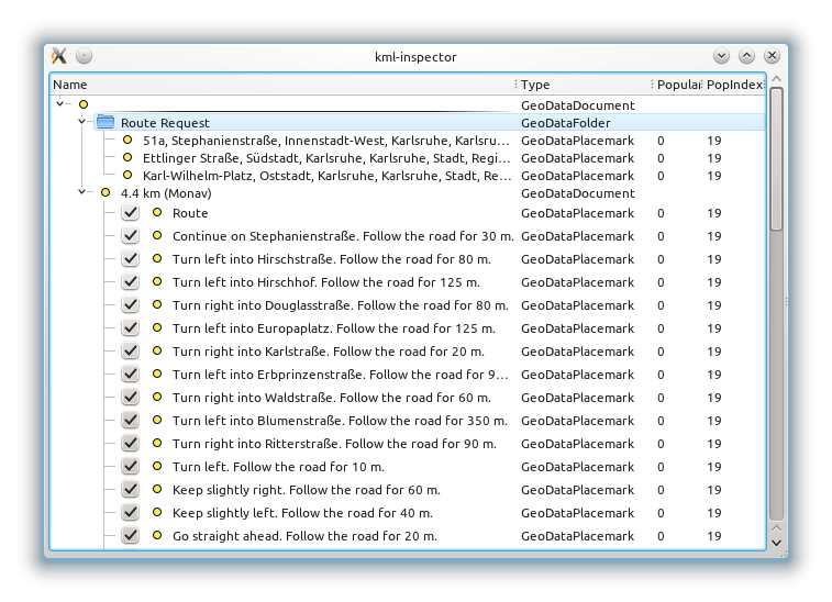
If things go fine, execute ./my_marble some-file.kml and you get a tree view of its structure similar to this screenshot (showing the structure of a route calculated with Marble):
- You need Qt and Marble development packages (or comparable git installations), version 1.3 (Marble library 0.13), shipped post KDE 4.8
- If Qt headers are not installed in /usr/include/qt4 on your system, change the path in the g++ call above accordingly.
- Likewise, add -I /path/to/marble/headers if they're not to be found in /usr/include

