Marble/HistoricalMaps/WorldMapSchagen1689: Difference between revisions
< Marble | HistoricalMaps
No edit summary |
No edit summary |
||
| Line 1: | Line 1: | ||
====Historical World Maps: G. van Schagen (1689)==== | ====Historical World Maps: G. van Schagen (1689)==== | ||
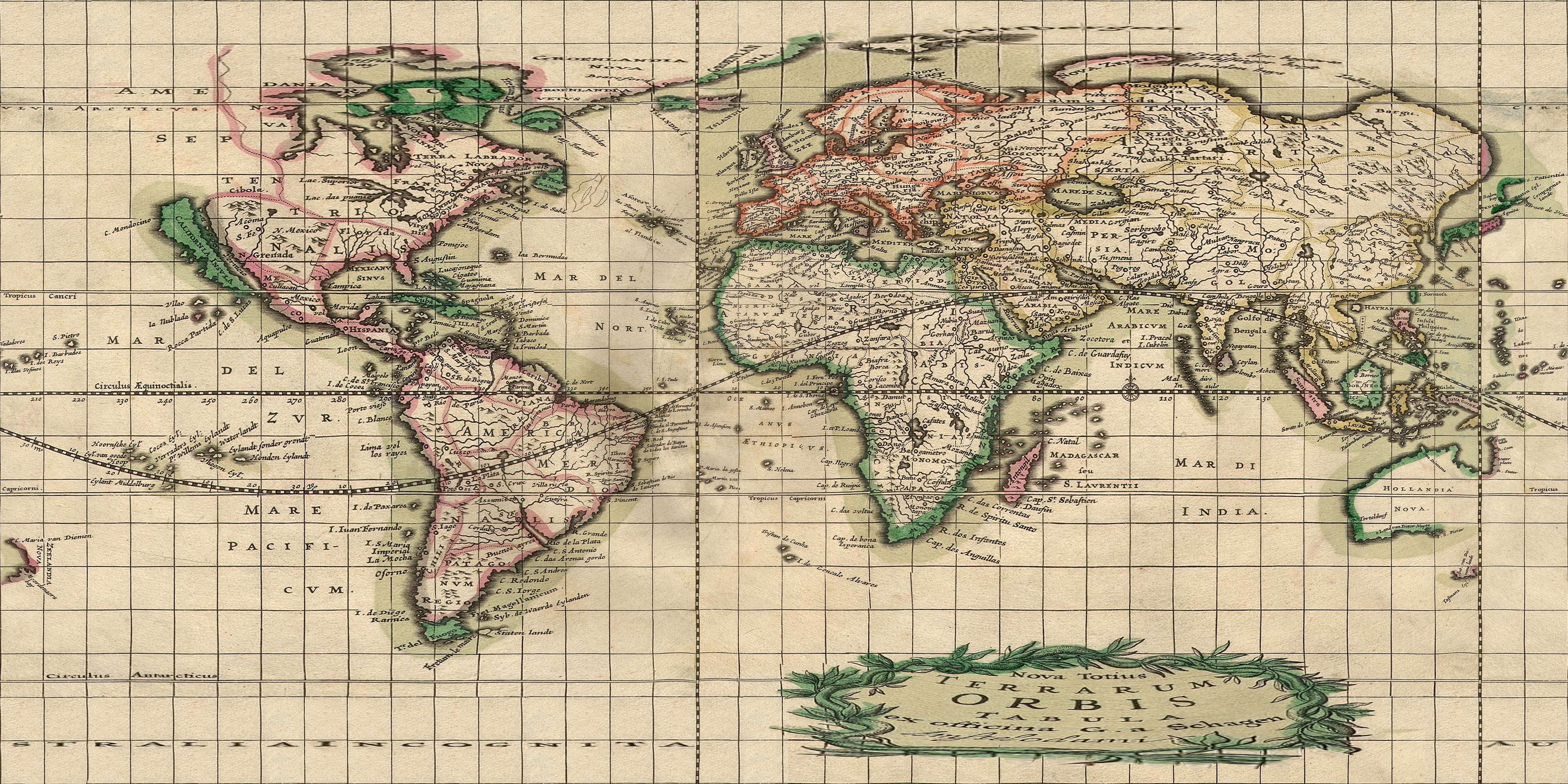
[[Image:schagen1689_orig_thumb.jpg|frame|none|Source: [http://commons.wikimedia.org/wiki/Image:World_Map_1689.JPG World Map 1689], Wikimedia Commons, License: Public Domain]] | [[Image:schagen1689_orig_thumb.jpg|frame|none|'''Source File''': [http://commons.wikimedia.org/wiki/Image:World_Map_1689.JPG World Map 1689], Wikimedia Commons, License: Public Domain]] | ||
[[Image:schagen1689_reprojected_thumb.jpg|frame|none|[http://developer.kde.org/~tackat/history/World_Map_1689.jpg | [[Image:schagen1689_reprojected_thumb.jpg|frame|none|'''Reprojected File''' [http://developer.kde.org/~tackat/history/World_Map_1689.jpg Reprojected World Map 1689], touched up and reprojected to plate carrée projection:]] | ||
====Interesting Aspects==== | ====Interesting Aspects==== | ||
* In China you can spot the chinese wall. | * In China you can spot the ''chinese wall''. | ||
* Where can you see New York on this map (look for New Amsterdam)? | * Where can you see New York on this map (look for New Amsterdam)? | ||
* The map shows California as an island (which was a common misconception at that time which also was depicted in other maps). | * The map shows ''California as an island'' (which was a common misconception at that time which also was depicted in other maps). | ||
* What are the names of Australia and Tasmania on this map? | * What are the names of Australia and Tasmania on this map? | ||
* On the map Greenland is apparently not a separate island. Instead it's depicted as part of the north american mainland. | * On the map Greenland is apparently not a separate island. Instead it's depicted as part of the north american mainland. | ||
Revision as of 17:00, 28 October 2008
Historical World Maps: G. van Schagen (1689)


Interesting Aspects
- In China you can spot the chinese wall.
- Where can you see New York on this map (look for New Amsterdam)?
- The map shows California as an island (which was a common misconception at that time which also was depicted in other maps).
- What are the names of Australia and Tasmania on this map?
- On the map Greenland is apparently not a separate island. Instead it's depicted as part of the north american mainland.
- The Prime Meridian is shifted by 20 degrees to the west compared to today's standards.
- The map seems to be globally pretty accurate in terms of shape. For Europe, Africa and much of America the geographic coordinates match surprisingly well, however it's noticably off for the eastern hemisphere.
Details:
- The map shows a region called "Nova Dania" ( "New Denmark", see also Jens Munk )