Marble/Runners/PaintingGeoDataLineString: Difference between revisions
CezarMocan (talk | contribs) No edit summary |
CezarMocan (talk | contribs) No edit summary |
||
| Line 11: | Line 11: | ||
}} | }} | ||
The previous tutorial showed how GeoPainter can be used in order to paint shapes and text at different coordinates of the map (through a GeoDataCoordinates parameter) | The previous tutorial showed how GeoPainter can be used in order to paint shapes and text at different coordinates of the map (through a GeoDataCoordinates parameter) in a [http://api.kde.org/4.x-api/kdeedu-apidocs/marble/html/classMarble_1_1MarbleWidget.html MarbleWidget]. Now, we'll show a new way of adding extra content to the globe: by painting GeoDataLineString's using our GeoPainter. | ||
Briefly, [http://api.kde.org/4.x-api/kdeedu-apidocs/marble/html/classMarble_1_1GeoDataLineString.html GeoDataLineString] is a tool class which implements LineStrings (also referred to as "polylines"), allowing us to store a contiguous set of line segments. As you will see in the example, it consists of several nodes (GeoDataCoordinate points), which are connected through line segments. | |||
In the previous tutorial you've seen how easy it is to embed a [http://api.kde.org/4.x-api/kdeedu-apidocs/marble/html/classMarble_1_1MarbleWidget.html MarbleWidget] into a Qt application: Just create a MarbleWidget, set a map theme on it and ... you're done already. | In the previous tutorial you've seen how easy it is to embed a [http://api.kde.org/4.x-api/kdeedu-apidocs/marble/html/classMarble_1_1MarbleWidget.html MarbleWidget] into a Qt application: Just create a MarbleWidget, set a map theme on it and ... you're done already. | ||
Revision as of 14:01, 22 May 2012
Editing Projects/Marble/PaintingGeoDataLineString
Languages: عربي | Asturianu | Català | Česky | Kaszëbsczi | Dansk | Deutsch | English | Esperanto | Español | Eesti | فارسی | Suomi | Français | Galego | Italiano | 日本語 | 한국어 | Norwegian | Polski | Português Brasileiro | Română | Русский | Svenska | Slovenčina | Slovenščina | српски | Türkçe | Tiếng Việt | Українська | 简体中文 | 繁體中文
| Tutorial Series | Marble C++ Tutorial |
| Previous | Tutorial 9 - Opening .kml, .gpx, ... files |
| What's Next | Tutorial 11 - Yet missing |
| Further Reading | n/a |
The previous tutorial showed how GeoPainter can be used in order to paint shapes and text at different coordinates of the map (through a GeoDataCoordinates parameter) in a MarbleWidget. Now, we'll show a new way of adding extra content to the globe: by painting GeoDataLineString's using our GeoPainter.
Briefly, GeoDataLineString is a tool class which implements LineStrings (also referred to as "polylines"), allowing us to store a contiguous set of line segments. As you will see in the example, it consists of several nodes (GeoDataCoordinate points), which are connected through line segments.
In the previous tutorial you've seen how easy it is to embed a MarbleWidget into a Qt application: Just create a MarbleWidget, set a map theme on it and ... you're done already.
Next we'll extend that example a bit and write our own little paint method to add some extra content to the globe. To facilitate this, Marble provides a painting hook called MarbleWidget::customPaint. It is called in between of the normal paint operations: After the background and tiles are painted, but before the top layers like float items (info boxes).
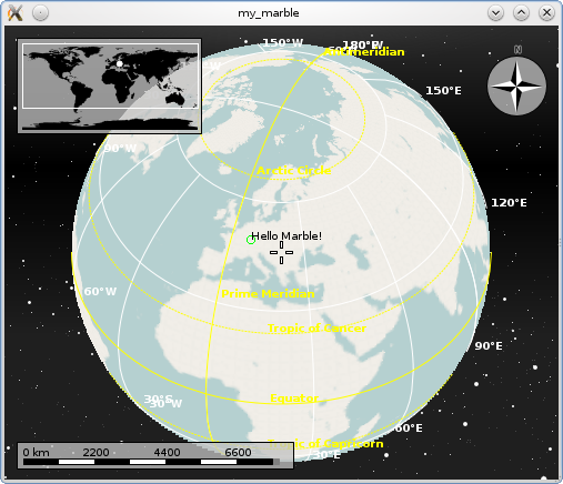
The customPaint operation is called with a GeoPainter: An extended QPainter which not only is able to paint at certain screen (pixel) positions, but also at certain geo (lat,lon) positions. We'll make use of that feature now. To keep things simple again, we just add a little 'Hello World' message indicated by a green circle.
#include <QtGui/QApplication>
#include <marble/MarbleWidget.h>
#include <marble/GeoPainter.h>

using namespace Marble;

class MyMarbleWidget : public MarbleWidget
{
public:
    virtual void customPaint(GeoPainter* painter);
};

void MyMarbleWidget::customPaint(GeoPainter* painter)
{
    GeoDataCoordinates home(8.4, 49.0, 0.0, GeoDataCoordinates::Degree);
    painter->setPen(Qt::green);
    painter->drawEllipse(home, 7, 7);
    painter->setPen(Qt::black);
    painter->drawText(home, "Hello Marble!");
}

int main(int argc, char** argv)
{
    QApplication app(argc,argv);
    MyMarbleWidget *mapWidget = new MyMarbleWidget;
    mapWidget->setMapThemeId("earth/openstreetmap/openstreetmap.dgml");
    mapWidget->show();
    return app.exec();
}
Save the code above as my_marble.cpp and compile it:
g++ -I /usr/include/qt4/ -o my_marble my_marble.cpp -lmarblewidget -lQtGui
If things go fine, execute ./my_marble and you end up with a globe view similar to this:
There may be situations where MarbleWidget::customPaint() does not suit your needs. This can be the case when you don't want to paint at the very top position (above all other items), or when subclassing MarbleWidget is not possible for some reason. In that case, have a look at the next chapter Drawing in Custom Layers

