Projects/KOffice/Geoshape: Difference between revisions
Appearance
Schmeisser (talk | contribs) No edit summary |
Schmeisser (talk | contribs) No edit summary |
||
| Line 26: | Line 26: | ||
make | make | ||
make install | make install | ||
===File Format=== | |||
<b>Warning:</b> The file format is simply based on what was simplest to save. If there's interest from other parties in a common format I would love to hear about it. Until then it might change in future. | |||
====Sample==== | |||
<pre> | |||
<draw:frame draw:style-name="gr3" draw:id="shape2" draw:layer="" svg:width="614.83584738243pt" svg:height="316.16681455191pt" draw:transform="matrix(1 0 0 1 24.1349pt 77.835pt)"> | |||
<koffice:map mapThemeId="earth/bluemarble/bluemarble.dgml" projection="Equirectangular" zoom="1050" centerLongitude="-9.40000000000" centerLatitude="9.11525490000"/> | |||
<draw:image xlink:type="simple" xlink:show="embed" xlink:actuate="onLoad" xlink:href="Pictures/image1.png"/> | |||
</draw:frame> | |||
</pre> | |||
This is a snippet from the xml-file of aboves screenshot. | |||
Revision as of 17:17, 2 March 2009
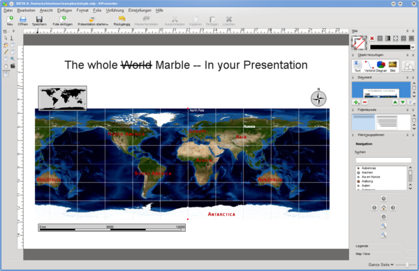
Screenshot

Description
geoshape is a so called shape, a plugin that can be used in (nearly) any Koffice2 application, like KWord, KPresenter and so on. At the moment it is limited to displaying a simple map, like they can be seen in Marble. Features like displaying adresses from a spreadsheet might follow later but are nowhere near implemented.
Current Features
- loading
- saving
- zoom/navigation
- search (no undo for that yet)
- undo/redo
- a fallback generic .png image for "less capable" office suits (read OpenOffice) is included
Ideas (no promise)
- searching and displaying points from a spreadsheet (adressess, gps, etc)
How to get it
can be found in playground/office/geoshape
svn co svn://anonsvn.kde.org/home/kde/trunk/playground/office/geoshape
needs at least
- koffice2 beta 5 or later
- marble from KDE 4.2 ( trunk not tested )
Compile it using the standard procedure
cmake .
make
make install
File Format
Warning: The file format is simply based on what was simplest to save. If there's interest from other parties in a common format I would love to hear about it. Until then it might change in future.
Sample
<draw:frame draw:style-name="gr3" draw:id="shape2" draw:layer="" svg:width="614.83584738243pt" svg:height="316.16681455191pt" draw:transform="matrix(1 0 0 1 24.1349pt 77.835pt)">
     <koffice:map mapThemeId="earth/bluemarble/bluemarble.dgml" projection="Equirectangular" zoom="1050" centerLongitude="-9.40000000000" centerLatitude="9.11525490000"/>
     <draw:image xlink:type="simple" xlink:show="embed" xlink:actuate="onLoad" xlink:href="Pictures/image1.png"/>
</draw:frame>
This is a snippet from the xml-file of aboves screenshot.
