Marble/LayerInterface: Difference between revisions
Earthwings (talk | contribs) Fix code formatting |
m Ochurlaud moved page Projects/Marble/LayerInterface to Marble/LayerInterface |
||
| (6 intermediate revisions by 5 users not shown) | |||
| Line 1: | Line 1: | ||
{{TutorialBrowser| | {{TutorialBrowser| | ||
| Line 6: | Line 6: | ||
name=Drawing in Custom Layers| | name=Drawing in Custom Layers| | ||
pre=[[Projects/Marble/MarbleGeoPainter|Tutorial | pre=[[Projects/Marble/MarbleGeoPainter|Tutorial 13 - Painting onto the map]]| | ||
next=[[Projects/Marble/ | next=[[Projects/Marble/Runners/PaintingGeoDataLineString|Tutorial 15 - Painting GeoDataLineString: Using the GeoPainter in order to paint a GeoDataLineString object]]| | ||
}} | }} | ||
| Line 140: | Line 140: | ||
QTimer seconds; | QTimer seconds; | ||
seconds.setInterval(1000); | seconds.setInterval(1000); | ||
QObject::connect(&seconds, SIGNAL(timeout()), mapWidget, SLOT( | QObject::connect(&seconds, SIGNAL(timeout()), mapWidget, SLOT(update())); | ||
seconds.start(); | seconds.start(); | ||
| Line 156: | Line 156: | ||
[[Image:Marble-paintlayer.png]] | [[Image:Marble-paintlayer.png]] | ||
The latest source code of this example can be found [https://quickgit.kde.org/?p=marble.git&a=blob&f=examples%2Fcpp%2Fcustom-layers%2Fmain.cpp here]. | |||
Latest revision as of 21:01, 10 March 2016
| Tutorial Series | Marble C++ Tutorial |
| Previous | Tutorial 13 - Painting onto the map |
| What's Next | Tutorial 15 - Painting GeoDataLineString: Using the GeoPainter in order to paint a GeoDataLineString object |
| Further Reading | n/a |
The previous tutorial showed how to override the customPaint() method in MarbleWidget to paint on top of the map. It is also possible to paint at different layer positions. This is similar to providing a z-order of elements being painted.
To achieve this, we'll take a look at an example. Instead of deriving from MarbleWidget, we create our own Marble::LayerInterface class. After passing it to Marble, it will be included in painting similar to how customPaint() was called. This time however we are able to specify at which layer to paint.
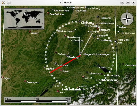
To illustrate the painting in different layers, the code below paints a clock and implements the ability to dynamically switch its layer position by pressing '+'. Notice how the current layer position is indicated in the window title. When painting in the "STARS" layer, you won't see anything -- we'll paint behind the map. In the "SURFACE" layer, city names and other placemarks will be painted on top of us. In contrast, "ORBIT" will make us paint over placemarks, while float items (info boxes) still paint above us. This will change when we paint in the "USER TOOLS" layer.
#include <marble/MarbleWidget.h>
#include <marble/MarbleMap.h>
#include <marble/MarbleModel.h>
#include <marble/GeoPainter.h>
#include <marble/LayerInterface.h>

#include <QtCore/QTime>
#include <QtCore/QTimer>
#include <QtGui/QApplication>
#include <QtGui/QKeyEvent>

using namespace Marble;

class MyPaintLayer : public QObject, public LayerInterface
{
public:
    // Constructor
    MyPaintLayer(MarbleWidget* widget);

    // Implemented from LayerInterface
    virtual QStringList renderPosition() const;

    // Implemented from LayerInterface
    virtual bool render( GeoPainter *painter, ViewportParams *viewport,
       const QString& renderPos = "NONE", GeoSceneLayer * layer = 0 );

    // Overriding QObject
    virtual bool eventFilter(QObject *obj, QEvent *event);

    GeoDataCoordinates approximate(const GeoDataCoordinates &base, qreal angle, qreal dist) const;

private:
    MarbleWidget* m_widget;

    int m_index;
};

MyPaintLayer::MyPaintLayer(MarbleWidget* widget) : m_widget(widget), m_index(0)
{
    // nothing to do
}

QStringList MyPaintLayer::renderPosition() const
{
    // We will paint in exactly one of the following layers.
    // The current one can be changed by pressing the '+' key
    QStringList layers = QStringList() << "SURFACE" << "HOVERS_ABOVE_SURFACE";
    layers << "ORBIT" << "USER_TOOLS" << "STARS";

    int index = m_index % layers.size();
    return QStringList() << layers.at(index);
}

bool MyPaintLayer::eventFilter(QObject *obj, QEvent *event)
{
    // Adjust the current layer when '+' is pressed
    if (event->type() == QEvent::KeyPress)
    {
        QKeyEvent *keyEvent = static_cast<QKeyEvent *>(event);
        if (keyEvent->key() == Qt::Key_Plus) {
            ++m_index;
            return true;
        }
    }

    return false;
}

GeoDataCoordinates MyPaintLayer::approximate(const GeoDataCoordinates &base, qreal angle, qreal dist) const
{
    // This is just a rough estimation that ignores projections.
    // It only works for short distances. Don't use in real code.
    GeoDataCoordinates::Unit deg = GeoDataCoordinates::Degree;
    return GeoDataCoordinates ( base.longitude(deg) + 1.5 * dist * sin(angle),
				base.latitude(deg) + dist * cos(angle), 0.0, deg);
}

bool MyPaintLayer::render( GeoPainter *painter, ViewportParams *viewport,
    const QString& renderPos, GeoSceneLayer * layer )
{
    // Have window title reflect the current paint layer
    m_widget->setWindowTitle(renderPosition().first());
    GeoDataCoordinates home(8.4, 48.0, 0.0, GeoDataCoordinates::Degree);
    QTime now = QTime::currentTime();

    painter->setRenderHint(QPainter::Antialiasing, true);

    // Large circle built by 60 small circles
    painter->setPen( QPen(QBrush(QColor::fromRgb(255,255,255,200)), 3.0, Qt::SolidLine, Qt::RoundCap ) );
    for (int i=0; i<60; ++i)
        painter->drawEllipse(approximate(home, M_PI * i / 30.0, 1.0), 5, 5);

    // hour, minute, second hand
    painter->drawLine(home, approximate(home, M_PI * now.minute() / 30.0, 0.75));
    painter->drawLine(home, approximate(home, M_PI * now.hour() / 6.0, 0.5));
    painter->setPen(QPen(QBrush(Qt::red), 4.0, Qt::SolidLine, Qt::RoundCap ));
    painter->drawLine(home, approximate(home, M_PI * now.second() / 30.0, 1.0));

    return true;
}

int main(int argc, char** argv)
{
    QApplication app(argc,argv);
    MarbleWidget *mapWidget = new MarbleWidget;

    // Create and register our paint layer
    MyPaintLayer* layer = new MyPaintLayer(mapWidget);
    // Uncomment for older versions of Marble:
    // mapWidget->map()->model()->addLayer(layer);
    mapWidget->addLayer(layer);

    // Install an event handler: Pressing + will change the layer we paint at
    mapWidget->installEventFilter(layer);

    // Finish widget creation.
    mapWidget->setMapThemeId("earth/bluemarble/bluemarble.dgml");
    mapWidget->show();

    // Update each second to give the clock second resolution
    QTimer seconds;
    seconds.setInterval(1000);
    QObject::connect(&seconds, SIGNAL(timeout()), mapWidget, SLOT(update()));
    seconds.start();

    return app.exec();
}
Save the code above as my_marble.cpp and compile it:
g++ -I /usr/include/qt4/ -o my_marble my_marble.cpp -lmarblewidget -lQtGui
If things go fine, execute ./my_marble and you end up with a globe view painting a little different interpretation of a world clock:
The latest source code of this example can be found here.

